When people pass by surveyors working on the streets, construction sites, and garden plots, many wonder what kind of “tripod” this is, where to look into the device, and what will I see there? What is the name of this device, and why is it here? Often it is idle curiosity. Sometimes they just try to understand and understand how it works and what it measures. Some simply work in related industries and want to expand their horizons.
There are very complex systems and ultra-precise instruments that are rarely used, and in the ordinary life of an engineer you will not encounter them. Let's try to briefly talk about the instruments that are mainly used by surveyors in applied geodesy. About those tripods and “sticks” that surveyors carry around.
A short historical sketch
The famous Russian professor-geodesist, who lived and worked at the turn of the 19th and 20th centuries, Lieutenant General Vasily Vasilyevich Vitkovsky called his specialty one of the most useful areas of knowledge. In his opinion, humanity needs to study the shape and surface of the Earth just as much as each of us needs to know our own home in detail.
It is not surprising that geodesy is developing all the time and has long been aimed not only at our individual planet, but also at the entire solar system and even the galaxy in the future. Along with the development of civilization, this science became very complicated, divided into several disciplines - and, naturally, began to set itself and solve increasingly complex problems. Moreover, both theoretical due to the increase in the number and scale of research, and practical due to the increase in the number of unique engineering structures and structures. This could not but lead, on the one hand, to increased requirements for measurement accuracy, and on the other, to the complication of equipment. This has become especially noticeable in the last 10-20 years due to the rapid development of electronics and the beginning of the widespread use of lasers.
More information about the origins of geodesy as a science can be found in a special article devoted to this educational topic.
Total station
It’s clear that measuring angles, lengths and heights with different instruments is not very convenient and quite time consuming. Therefore, for those cases when it is necessary to carry out several types of measurements, there are combined instruments, such as a tacheometer. This is the most modern electro-optical device that allows you to measure any lengths, height differences and horizontal angles.
In most cases, this device is sufficient to record all necessary measurements on an object, provided that the accuracy of the device corresponds to the type of work. It is these devices, for the most part, that you can see on construction sites, on neighbors’ plots and along the roads of our country. At this stage of technology development, tacheometers are the most popular and universal instruments for carrying out geodetic measurements. Topographical surveys, land surveying and axes, for example, are impossible without a tacheometer.
Types and principle of operation of the device
The general appearance of the product is a wheel on a long handle, reminiscent of a children's toy. Despite its frivolous appearance, the device is accurate, reliable and in some cases an indispensable measuring instrument.
A road wheel curvimeter is most often used to measure extended distances, which includes measuring areas with non-uniform terrain. Such a device provides more accurate measurement results than a modern rangefinder based on laser technology. There are road and topographic curvimeters.
Topographic curvimeter
As the name suggests, topographic instruments are designed to estimate distances on a map. Accordingly, the size and weight of the products are small and can be issued in the form of key rings or pens.
Mechanical topographic measuring instruments offer a number of advantages for use in the field. This is simplicity of design, independence from power sources, resistance to weather conditions.
For indoor work, meters with electronic filling and software are used.
Road curvimeter
An indispensable measuring tool for road work and measuring the parameters of objects under construction, determining curved or extended straight sections. Also, as in the case of topographic meters, they can be mechanical or electronic.
The main difference in the measurement principle is the accuracy per unit distance. Mechanical curvimeters can accumulate error over large distances, so it is recommended to break long areas into small sections .
Electronic devices are not prone to the accumulation of errors, but require careful handling and strict adherence to operating rules. The digital road wheel allows you to make the most accurate calculations when measuring an area. When carrying out preparatory construction work, this is very important, since the quality and safety of the constructed facility will depend on the accuracy of the measurements.
Read also: Life hack antenna for TV
Digital or computer curvimeters are made from high-tech materials that increase the wear resistance of the device. They may have a number of other useful functions that are necessary when measuring a site. Using an on-board computer allows you to remember several measurements, save the calculations made and previous measurements.
Level
In many cases there is no need for bulkier and much more expensive and difficult to use total stations. In the construction of buildings, roads and other structures, after the planned location of the object is determined, you only need to control the height, level and verticality of the surfaces. The level easily copes with these functions. Its main task is to measure excesses between objects. There are electronic, optical, laser, auto-installation levels and others. In many cases, it is more convenient and expedient to use levels - for example, when monitoring settlements of buildings and structures, high-precision levels with automatic installation are used rather than total stations - again due to the high cost of the latter. To sum up the use of levels, we can say that most often they are used directly in the construction process due to their ease of use and relative cheapness.
GPS equipment
GPS modules or receivers accompany us in everyday life in our phones, navigators, tablets, etc. They are designed to help us navigate the area and not get lost in the urban jungle. However, they have little in common with geodetic GPS equipment.
Surveyors need these devices not for terrain orientation, but to accurately determine the location of the “dish” (usually the manufacturers of GPS receivers adhere to this form). The error is usually 0.5-2 centimeters relative to the nearest point of the State Geodetic Network (GGS). While conventional navigators give a location error of about 10-20 meters, which is unacceptable in the work of a surveyor. But there are many factors that very often negatively affect the magnitude of the error in geodetic measurements using GPS equipment. Therefore, it is not enough to simply purchase an expensive “dish” and start determining the location of neighboring fences, for example, like a regular navigator. Without proper calibration and subsequent processing of measurements, nothing will come of it.
In general, if you see a surveyor with a “dish” on a pole, know that he is determining the exact location of the point above which the receiver is located. Recently, the transfer of site boundaries to the terrain is carried out almost exclusively by the GPS method. It's much faster and more convenient.
11.2. Mechanical distance measuring instruments
Mechanical instruments for directly measuring distances include steel surveying tapes and tape measures.
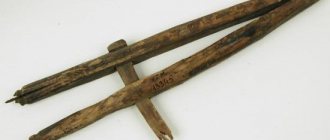
Land surveying tapes are made from steel strip 15–20 mm wide and 0.4–0.5 mm thick. They are designated LZ-20, LZ-24, LZ-50 in accordance with the length of 20, 24 or 50 m between the end strokes of the tape at a tension of 98 N. The ends of the tape (Fig. 11.1) are equipped with handles; opposite the end strokes, cutouts are made in the tape for securing the tape with pins in a taut state on the surface of the earth. The meter divisions of the tape are secured with digitized plates, the half meters are marked with rivets, and the decimeter divisions are marked with round holes. Reading accuracy t ≈ 1 cm.
When not in use, the tape should be wound around the frame in the form of a ring. Complete with LZ type tape, a set of 6 or 11 metal pins is used.
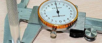
Roulettes are manufactured by many foreign companies under various names. In Russia, tape measures of the 2nd accuracy class OPK2-20 ANT/1, OPK2-30 ANT/1, OPK2-50 ANT/1 are produced. They are made of steel tape 1 cm wide and 20, 30 and 50 m long, respectively. The tape is covered with a protective film, and a linear scale with a division value of 1 mm is applied to it. The reading accuracy on such a scale is t ≈ 0.2–0.5 mm.
A tape measure of the 3rd accuracy class OPK3-20 ANT/10, 20 m long, is characterized by a scale with a division value of 10 mm (reading accuracy on the scale t ≈ 2–5 mm). In OPK2 and OPK3 roulettes, the tapes are wound on a frame. Pins are not supplied with the tape measures.
Read also: The best TV wall mount
Note. In the roulette codes, letters and numbers indicate: O – open body (fork or cross); Z – closed body; P – flat tape (section not in the shape of a gutter); K – exhaust ring; 2 or 3 – accuracy class; A – removal of the scale from the beginning of the tape; N or U – stainless or carbon steel; T – scale strokes are etched; /1 or /10 – in the denominator of the fraction, the scale division value is 1 or 10 mm.
Rice. 11.1. Land surveying tape LZ-20:
a – meter and decimeter divisions; b – on the frame; c – studs
The working tension of all LZ tapes and tape measures is 98 N.
Since surveying tapes and tape measures are not fundamentally different, in the future we will use their general name - measuring tapes.
Comparing measuring tapes is a comparison of the working length of the tape with the length of the working standard. Tapes in operation are annually certified (they are compared with the issuance of a document for permission to use) in the metrological supervision laboratory. The actual length of the working belt is increased
Accurate measurement of distances, and especially non-straight sections, is necessary in many areas of activity. The construction of civil and industrial facilities, road work and even the assessment of distances on a topographic map is carried out using a special measuring device - a curvimeter.
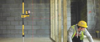
Tripod
A very simple surveyor's tool. Many people have encountered tripods when shooting photographs or films using professional equipment. Surveyors also use special equipment that cannot do without tripods. Geodesics differ from the rest mainly in their simplicity of design, ease of use and “indestructibility”. After all, you have to work in less than ideal conditions. The main task of a geodetic tripod is to immovably fix the device that is installed on it. First, a tribrach is placed on the tripod - a special device for centering over a certain point, if necessary, and leveling the device. Then a tacheometer, level, etc. device is installed. There are wooden, metal and composite tripods. Recently, the most “advanced” ones are fiberglass tripods. They are very light, durable... but so far unreasonably expensive.
What to look for when choosing a curvimeter: tips and tricks
When choosing a curvimeter model, you should pay attention to some nuances:
- Before purchasing, you should decide on the type of device: mechanical or electronic. The choice of one model or another depends on the purpose of using the mechanism;
- One of the most important parameters that you should pay attention to when purchasing is the maximum measurement limit. For domestic use, you can purchase models with a limit of 1 kilometer, however, for more professional use, preference should be given to a model with a rating of at least 10 km;
- Another important nuance is the presence of a memory function in the curvimeter. This is very important if you need to save the results;
- Before making your final purchase, we recommend that you carefully inspect the model for any visible damage. If there are scratches or abrasions on the mechanism, it is better to purchase some other device.
Video - DIY wheel distance meter
Veshka
Also a fairly simple geodetic instrument. It looks like a round stick about 1.8m high. However, many poles are retractable and can be up to 6 meters high. At the top there can be both a reflector and a GPS receiver. The reflector can be of different shapes and designs. Its main task is to reflect the signal sent by the rangefinder. Its feature is that the beam/signal coming from the measuring device is reflected exactly back.
Ultimately, where the reflector or receiver is located on the geodetic pole, the location of the measured point is determined.
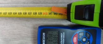
Laser roulette
It appeared relatively recently in geodetic teams, as previously it was quite expensive and difficult to use. And to this day it is not the only device for directly measuring distances on an object. Convenient to use over short distances and indoors. It is not often used in outdoor conditions, since it is necessary to have a surface onto which the laser beam can be aimed. Another disadvantage of many models without an optical sight is the poor visibility of the laser dot on brightly lit surfaces.
In view of this, it is now still quite common to use steel tape measures up to 50m long. Longer lengths are not available, so distances greater than 50 meters are sources of error due to several measurement steps. Measurements need to be carried out together, and the sagging of the tape causes some error in the measurements.
As a result, laser tape measures are used everywhere by cadastral engineers and surveyors in cases where it is appropriate and possible. Almost all measurements of premises for examination of premises or technical plans cannot be done without it. In other cases, a good old steel tape measure helps.
History and evolution of rangefinders
Before the advent of electronic devices, optical distance measuring devices were used to determine distance . Observational and geodetic instruments were equipped with angular scales, which made it possible to use methods for indirectly calculating the distance to objects.
There were also more complex optical instruments for measurements. These were mainly devices based on the phenomenon of parallax. Cameras of the last century were equipped with similar systems. In terms of accuracy, all of these optical devices had a large range of reading errors, both depending on the measuring range and the skills of the users.
The theoretical basis for creating active rangefinder devices, which are based on the principle of sending a signal in the direction of an object with subsequent analysis of the returned reflection, was ready at the beginning of the 20th century. The impetus for the practical implementation of this principle was the Second World War - the armies of the world needed instant measurement of distances to targets. This is how industrial designs of radars and echo sounders appeared and rapidly evolved. These devices, which used radio waves or ultrasound as a signal, were quite cumbersome and unsuitable for personal use.
Pipe cable detector
A device accompanying engineering and geodetic surveys for plotting underground communications on the plan. Often the kit includes a generator that is installed on the communication in its visible part. It generates vibrations that are detected by the receiver. After identifying the turning points of communications, they are applied to the geobase or topographic plan. The cable detector can also measure the depth of communications with an accuracy of 0.01 m.
check
We told you briefly about geodetic instruments and tools needed in applied geodesy. We hope that we have helped you understand the intricacies of tripods and “sticks” with which people who call themselves surveyors work.
Get acquainted with the cost of our work